| Earth's Great Cataclysm |
||||
The fracturing of the contents The creation of Sand and Gravel The deposition of the sedimentary layers Mountains and Basin Formations Formation of petroleum and coals
|
This is a
brief summary of a cataclysmic event that occurred in the not too distant past. The
evidence is everywhere. Take a brief tour of this event and give it time to gel in your
own universe. As you tour the country imagine these mechanics at work and it becomes easy
to explain all the geology you see in terms of a rapid mega size cataclysmic event.
The earth before the great cataclysm is a relatively flat planet with shallow seas and gentle sloping hills. There were no continents with their continental shelves or ocean basins. The earth had seas in all the low places. These were all on top of the continental crust. The deepest sea was probably no more than 1,000 feet and the highest hill or mountain 1,000 feet high. The earth probably had a 360 day year and a rotational axis at a perfect 90 degrees. This the most logical reason that civilization divided a full circle into 360 degrees. According to scripture the rainbow was a sign that the earth would never be destroyed by flood again. If there were no rainbows that means direct sunlight did not reach the earth , so then diffused light conditions means there was a dense cloud cover. So lets assume for the moment there must have been a canopy of dense vapor that shrouded the earth and bound up a tremendous amount of water. It hid the sun and insulated the earth. There was no rain, wind, snow or weather of any kind, only gentle breezes. The temperature and humidity was consistent from pole to equator. There was abundant life in all the land and landlocked smaller seas from pole to pole.
Job 38 4 Where waste thou when I laid the foundations of the earth? declare, if thou hast understanding. 9 When I made the cloud the garment thereof, and thick darkness a swaddling band for it, Earth's Structure The earth is structured in layers. We can get an inside glimpse by the measurements of the speed and timing of the S waves earthquakes generate. When an earthquake occurs it generates waves that spread outward in globes from the focus of the quake. These waves are partially reflected when the wave meets a boundary of two layers of distinctly different densities. This is like the light that is partially reflected on a window pane or what happens to the image of a pencil that is partially submerged in water. It looks bent because the boundary of the air and water bends the light. Boundaries of density variations also reflect vibration waves. Some of the earthquake wave bounces back and some of the wave is refracted or bent at each interface in the earth's layers. These interfaces occur when there is a distinct boundary between materials of different densities. Measuring the relative speeds and deflection of these waves gives us some idea of the depth, density and properties of these layers. Looking at the plot of s wave velocities we can graph the approximate boundaries and deduct the character of the layer. The ridged continental crust was between 50 and 70 kilometers thick and covered the entire sphere of the earth. This ridged crust is floating on denser semi molten or plastic state mixed materials that is approximately 150 kilometers deep. |
|||
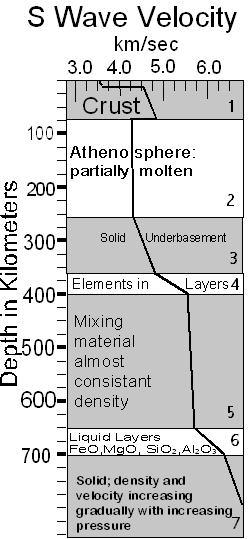 |
This
chart shows S wave velocities changes. The line starting at the top has a short distance of consistent speed before it turns to the right. This shows the sedimentary crust. Where the line rapidly increases in speed, is where the sedimentary crust meets the solid granite cranton. Then the meat of the continental cranton is represented by the downward angled line. The cranton increases in density consistently up to where it meets the asthenosphere. Section 2 The rate slows dramatically where the crust is contacting the asthenosphere. This next layer is a plastic mix and the speed stays consistent at approximately 4.3 kps for its entire 150 kilometer thickness. This confirms it must be all the same density and consistency. It is constantly mixing and isn't stratified. The asthenosphere ends at approximately the 250 kilometers depth. The next layer is a solid matrix I call the under basement.
|
|||
Section 3 The section after the Asthenosphere is stratified and probably solid. Notice the change in speed of the s wave velocities as we go deeper. I think this is due to a mix of partially stratified elements that increase in density as you go deeper. Section 4 Next is layer that is increasing in denser faster as we go deeper. This may be stratified elements. IF we could develop more detail of the speed changes that could probably be verified. Section 5 The next layer is has a very consistent wave speed indicating it has a consistent density. Layer 6 increases in density very rapidly and probably contains sections of oxidized metals The present theories conclude that S waves do not propagate in liquid layers. But I think these are like plastic layers compressed to respond like solids. So while this is partially speculative, I think the evidence clearly shows a variety of layers of varying characteristics. This is completely different than the current theories of how the earth is structured. The point of this is to establish that the earth before the catastrophe had a more organized structure below the crust. The layers of material below the crust were stratified by density. This information is important and proofs will be offered in the following text. The approach of an interloper. Our solar system had a visitor that passed within the orbit of Jupiter possibly as close as the orbit of earth. Its gravity combined with its speed and trajectory caused havoc to earth and other planets. The effect on earth is chronicled in the Bible and in the geological features we can see today. The following is a plausible scenario. The star or mass approached the solar system and begins to effect earth. Its heat and radiation begins to alter the cloud canopy and rain begins for the first time on earth. Job 38 Verse 32 Canst thou bring forth Mazzaroth in his season? or canst thou guide Arcturus with his sons? Then the shallow seas begin to develop exaggerated tides. These become large tides building as the seas and lakes are attracted by the visitors gravity. These tides grow progressively in size each day as the interloper approaches closer. Seas begin running up and over their containment hills. The water is progressing westward and begins to gather towards the equator. The canopy has broken down and all the earth begins to develop weather systems as the poles get colder and air masses start moving around. The moisture condenses out as rain and falls to earth in torrents. Genesis 7 6 And Noah was six hundred years old when the flood of waters was upon the earth. 7 And Noah went in, and his sons, and his wife, and his sons' wives with him, into the ark, because of the waters of the flood. 10 And it came to pass after seven days, that the waters of the flood were upon the earth. 11 In the six hundredth year of Noah's life, in the second month, the seventeenth day of the month, the same day were all the fountains of the great deep broken up, and the windows of heaven were opened. 12 And the rain was upon the earth forty days and forty nights. 17 And the flood was forty days upon the earth; and the waters increased, and bare up the ark, and it was lift up above the earth. 18 And the waters prevailed, and were increased greatly upon the earth; and the ark went upon the face of the waters. 19 And the waters prevailed exceedingly upon the earth; and all the high hills, that were under the whole heaven, were covered. 20 Fifteen cubits upward did the waters prevail; and the mountains were covered. 24 And the waters prevailed upon the earth an hundred and fifty days. Genesis 9 12 And God said, This is the token of the covenant which I make between me and you and every living creature that is with you, for perpetual generations; 13 I do set my bow in the cloud, and it shall be for a token of a covenant between me and the earth. 14 And it shall come to pass, when I bring a cloud over the earth, that the bow shall be seen in the cloud:
These tides grow as the water accumulates at the equator and ammasses into tidal waves that move out of their basins and over their containment's and begin to migrate across the landscape. Each day as the earth rotates the waters move farther west trying to follow the gravity source. They begin to accumulate together into larger and larger volumes. The seas gathered progressively together. The effects become more aggressive and begin scouring the high places and depositing the material into the lows. It is in these shallow deposits in the initial events where we find fossils of animals footprints. Some life survived the initial daily onslaught of water for weeks and months. Their prints are made in the fresh mud and then are covered the next day by another layer of mud, preserving them for later discovery. Fishes and other sea life are left stranded on freshly deposited sand layers. They die in situ and then are covered by the next onslaught of water and sediment. The first species to be fossilized are those that lived at the bottom of the seas in the mud. Then progressively as the events grew in intensity larger and larger forms succumbed and were buried in the mud. The visitor approaches closer and the events become increasingly larger. The tidal waves become gigantic tsunamis. The gravity eventually pulls the water into a waves of mountainous proportions attaining miles in height. They became great crashing waves of immense power. Psalm 33 7 He gathereth the waters of the sea together as an heap: he layeth up the depth in storehouses. Psalm 93 3 The floods have lifted up, O LORD, the floods have lifted up their voice; the floods lift up their waves. 4 The LORD on high is mightier than the noise of many waters, yea, than the mighty waves of the sea. The gigantic waves move across the earth and end up breaking. This occurred as the water that surges towards the east to meet the attraction, moves into the mound of water moving to the west following the gravity. The west moving water gains speed and the awesome mountain of water, possibly 50,000 feet or more, peaks and pitches into a breaking wave, crashing onto the earth. The awesome power produces incredible scouring and eroding of the earth. It plucks and carves away at the land that it impacts. If you have felt the force of a small wave or seen the results of moving water just imagine the force of a mountain of water! Here we have millions of years of Unitarian erosion occurring in minutes. This eroded material would then be thoroughly ground up and mixed in the turbulence Creating the blends of materials we see in the geological layers of the earth. The gravity effect at any location comes and goes as the earth rotates at approximately 1,000 miles per hour. The gathering water cannot move at this pace so it repeatedly mounds up and breaks in gigantic crashing waves, scouring the earth and depositing layers. Unable to keep up with the earth's rotation the mound of water would slow down. The load of material would settle out according to the conditions of the event. The material might segregate in areas and stay mixed in others depending on the terrain and the mix of variables the event contained. This settling could be drawn out over hundreds of miles in tapering beds or piled up against a slipped fault. This breaking point occurs randomly. Sometimes the breaking event was relatively mild at other times severe. Some areas were hit with repeated events while others may never have received a full breaking wave. This process accounts for the variety of layers, types of mixes and the thickness of deposits we find around the earth. It also accounts for the areas that have been severely eroded and others were we find the fossils at ground level.
The Fracturing of the Continents The whole area of crustal fracturing is somewhat glossed over in traditional geology. How did the earth get so fractured? The fractures occur everywhere and they go very deep in places. The planet formed with layers each one a complete shell. We could assume that the outside crust was also formed as a complete shell. This shell was completely supported by the plastic asthenosphere that it floated on. We could understand a massive meteor cracking the crust but that would produce a distinctive fracture. The fracturing is everywhere. The crustal shell is also seventy kilometers thick. How did the initial events occur that destroyed this thick rigid shell? What happened to all the missing crystal material? The idea that the crust which is floating on the asthenosphere can all of a sudden begin to plunge downward into material that is a lot denser than itself. Have you ever tried to push a float underwater. It doesn't want to go downward. The idea that the crust can be pushed horizontally and then dive downward is like taking an air mattress float and pushing it to the side of a pool and making the other end plunge downward into the water. No way. Can't happen. This feeble theory is all that traditional geology has to explain the missing crust material. But as you will see there is a much more elegant explanation. Psalm 60 2. Thou hast made the earth to tremble; thou hast broken it: heal the breaches thereof; for it shaketh. This cataclysmic event provides the mechanics to explain this also. The interloper comes much closer to the earth than the sun, and the force of its gravity was exceedingly great. The earth became slightly elongated as the sun and the interloper compete and try to pull the earth apart. The earth's rigid brittle crust is forced to rotate around a new oval or egg shape. This resulted in extensive fracturing. The process is like rolling a hard boiled egg on a counter. A very slight pressure deforms the shape of the interior and the rigid shell will not flex so it cracks at regular intervals completely through the shell. These crustal cracks are easily seen all over the planet. They are the planets canyons. The Rio Grande River has many places along its length where the crevasse snakes along with vertical parallel walls. You can imagine removing the debris from the bottom of the canyon and the two sides would fit back together perfectly. The canyon it flows through west of Taos New Mexico and the canyon in the Big Bend of Texas are great examples. These canyons were not water cut they are fractures where the crust distended and the two sides stayed apart. The river just follows the fracture. This fracturing leads to another feature of the crust the formation of clay sand and gravel. |
||||
| Crustal Flexing As the earth rotates the shell is forced to rotate around a slightly elongated shape. This caused the initial fracturing and caused and interesting conveying process where material was brought from great depths to the surface. Just like rolling an egg on a counter. The fractures open and shut repeatedly as the crust rolls around the oblong shape. When the crust is passing the tighter arc at each end of the oblong shape the alignment of each side of the fracture is separated at the top. When the fissure rotates past the gravity source to the flatter arc area the alignment of each face of the fissure is closed at the top and opens at the bottom. |
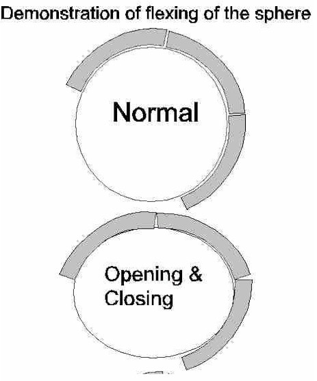
The process of the flexing crust opened the earth's shell down to the super hot dense layers underneath which exploded upward. This action forced pure elements into veins all over the world. It forced the quartz oxide high into the atmosphere where it congealed into the gravel and sand that covers the surface of the earth. |
|||
| Genesis 7
11 In the six hundredth year of Noah's life, in the second month, the seventeenth day of the month, the same day were all the fountains of the great deep broken up, and the windows of heaven were opened .The Creation of Clay, Sand & Gravel
The current theories of the formation of sand and gravel are a vague combination of glaciers, rivers and beach action. While the rivers and beaches can form gravel they grind rocks into gravel. Microscopic examination shows the scratches and grinding profiles that are typical of tumbled material. None of these activities can really explain the deep beds of gravel found all over the earth that do not have the scratches typical grinding marks. The catastrophe formed gravel has mirror finishes on their surfaces. Typical geology explains all these beds of gravel as the remnants of older mountains. All the other material has moved far away and left the gravel. However typical mountains do not contain large amounts of flint and quartz deposits. None that contain large deposits of the materials that make up gravel. Yet we find gravel all over the surface of the earth. There is gravel up in the highest mountain passes of the Rocky Mountains. We find gravel on islands in the Caribbean. Gravel is mostly on the surface. There is no gravel to speak of deep in the geologic layers. The gravel is mostly on the surface. Gravel is mostly found near large faults. Gravel also has features that cannot be explained by grinding and tumbling. There is gravel that has very smooth surfaces that show no signs of abrasion. Some gravel has the imprints of shells in them. If the gravel was made by tumbling down mountain streams how did it get the shell impressions? 
There is also gravel that has impact fractures yet the gravel did not fall apart. This could only occur if the gravel was plastic on the inside and brittle on the outside. Psalm 114 8 Which turned the rock into a standing water, the flint into a fountain of waters. The process that formed gravel is found in the flexing and opening of the crust. As the crust opened the material was released from its high pressure and blasted to the surface. It was pumped and squeezed to the surface. As the crustal fissure is rotated around the oval earth's core the crack opens at the bottom where molten material is drawn into the crack. When this section of crust rotates again around the tighter arc the material is forced upward and out the top. This pumps the molten material upward higher up the crevasse where it is forced upward and out as the crevasse slams back shut. This is material that has been at extremely high temperatures and pressures, suddenly arriving at the surface from the depths it exploded high upward where it had enough air time to harden into solid globes. This rapid decompression causes the material to explode upward as the pressure is released spraying the molten materials into the air. The event is described in the Bible as the opening of the fountains of the deep. This is the process that formed all the sands and clays that are intermixed in the layers of the deposited sedimentary crust. Certain conditions would have material arrive at the surface as a gaseous vapor. In these cases the materials condensed into clays and sands. The larger vapor droplets formed larger grained material. These sometimes were shattered into coarse grained sands by contact with water and rapid cooling. The larger droplets and globules formed the gravel that is littered over the earth in deep beds. All around the planet are areas of large amounts of specific types of sands and gravel. These are evidence of many different specific sets of conditions creating particular mixes from certain depths These exploding upward at a specific rate into a specific environment at the surface. This wide variety of conditions formed all the different varieties of clays, sands and gravel. Some materials were very thin and formed fine clays of specific materials. Some mixes were thicker and formed droplets of quartz that came upward into a sea and shattered into coarse quartz sands. Others formed globules of gravel. See the Clay Sand and Gravel page for more details. |
||||
| The deposition of the sedimentary layers The sedimentary layers are very difficult to explain without knowing the nature of the cataclysm that occurred to earth. Traditional Uniformitarian theories do not explain what we find in these layers very well plus they do not account for the vast periods of time in between the layers. Another problem geologists have is that many of the layers of sediments have foot prints, fossils with all their skin, scales and meat in place. There are also other marks in layers. Some made water movement such as ripples, tide marks and wave marks. There are also dry land marks, like rain drops and footprints, that are well preserved. These were covered by the next layer of sediment. The time between these layers was so short that the foot print marks or water marks were not disturbed. Now lets think about how long foot prints last at the beach or on a mud flat around a river. This proves that there was no time in between the layers or these features would be obliterated. There are also no soils in between the layers. There are very distinct layers separate in composition but directly in contact with the other. How is this all possible? By using the mechanics of the cataclysm all existing conditions are easily explained. The layers were all formed rapidly by water deposition. Each layer has a consistent appearance along its length. The length can taper but it is relatively consistent in composition throughout its length. Some layers run hundreds of miles. They contain various types of materials including lime mud, limestone, sandstone, shale and conglomerates. The deposits were generally laid down in horizontal layers but some conditions could lay down layers at an angle or rapid tapered beds. The material that the moving water and turbulent forces eroded were combined with the clays and sands that were being expelled. These were deposited as the water calmed. The carried load dropped to the bottom. The process was a daily cycle of erosion transport and deposition. Erosion varied as the depth of the water varied and the location of the mounding water and breaking waves changed. The deposition varied by the same process and the areas proximity to clay and sand ejection sites. At times there were several days in a row when the same material was laid down. At other times, when a new fracture opened up, and the area had a completely new type of deposit. At the same time the erosion and deposition was occurring the crust was also fracturing and moving up and down. Here we have a day simulating millions of years Unitarian erosion in a few hours followed by millions of years of Unitarian deposition during the other half of the daily rotation. One day to do what millions of years are said to accomplish in the Uniformitarian view. The deep limestone beds like the deposits seen in the Grand Canyon were composed of material from nearby large seas that had abundant limestone reefs. This sea was scoured by the tremendous water erosion and the lime mud as well as all the sea life was ground up together and re-deposited in deep beds of a consistent mix of lime/mud/broken shell fragment materials. The sandstones were the result of a large fractures belching tremendous volumes of specific types of sands. Shale layers are combinations of compressed clays laced with oils from sea and animal life. Different sets of conditions create different layers. |
||||
| Continental Crust Removal and the Shifting of the Continental Crust How come there are definite continents that have vertical cliffs at their perimeters? Why are the ocean basins thin and have no sedimentary layers? Why are the ocean basins made out of completely different materials than the continental crust? The mechanics of this event explain how this all happened. Isaiah 24 19 The earth is utterly broken down, the earth is clean dissolved, the earth is moved exceedingly. 20 The earth shall reel to and fro like a drunkard, and shall be removed like a cottage; and the transgression thereof shall be heavy upon it; and it shall fall, and not rise again. The gravity from the visitor finally becomes over whelming and the crust, oceans and atmosphere all are lifted up into a great heap. The earth’s crust snaps loose and more than half of the crust is dragged off the earth along with most of the water and atmosphere. It slides off the earth and is towed into space trailing the interloper. We know the atmosphere was totally removed by certain phrases in Genesis. One of the most interesting is that Noah was instructed to pitch the ark both inside and outside. The pitch on the outside was to keep the water out. The pitch on the inside was to keep the air inside. Genesis 6 14 Make thee an ark of gopher wood; rooms shalt thou make in the ark, and shalt pitch it within and without with pitch. 17 And, behold, I, even I, do bring a flood of waters upon the earth, to destroy all flesh, wherein is the breath of life, from under heaven; and every thing that is in the earth shall die. Genesis 7 15 And they went in unto Noah into the ark, two and two of all flesh, wherein is the breath of life. 22 All in whose nostrils was the breath of life, of all that was in the dry land, died. Notice how Genesis talks about the breath of life was in the ark but not outside the ark, so the atmosphere was removed for a period of time. At the moment of the crust departure many other things happened. Some sections lifted upward, and then fall back. Some of the material of the liquid layers below the crust also went. The under basement itself cracked and some of this shell and the layers below it were also removed. This is a cataclysmic activity of immense proportions. It boggles the mind The remaining crust less than half of the original full shell breaks up into the contents. These sections are very shattered and they are all moving away from each other towards the low spot where the crust and interior materials were ripped out. The earth was slowed a small amount by the dragging of the crust as it was pulled off. The effect was like touching the moving disk of a gyroscope and it caused the wobble in earth's axis.
Chapter 8 1 And God remembered Noah, and every living thing, and all the cattle that was with him in the ark: and God made a wind to pass over the earth, and the waters assuaged; 2 The fountains also of the deep and the windows of heaven were stopped, and the rain from heaven was restrained; 3 And the waters returned from off the earth continually: and after the end of the hundred and fifty days the waters were abated. |
||||
|
The removal of the mass set up additional shape oscillations of the earth’s mass. The action is like a water balloon or a globule of water in weightlessness of space. This mass oscillation started as the material that did not separate, fell back onto the earth. Imagine an amount of mass shaped much like a cone that might have been hundreds of miles high and wide at the base. Its momentum on impact caused the earth to elongate in one axis which rebounded into another axis. The process was violent at first and dissipated over time. It had sub features like the ringing of a bell that ended up going in all directions at the same time. The oscillations caused the remaining continents to move in a back and fourth surging motion as they moved to their new locations. This surging created the sliding transform fault features in the ocean mid rift rises. See the Ocean Basin page for more data. It also caused huge injections of plastic granite material to surge upward. These up thrusts occurred at the focal point of the waves from the oscillations. Mountains raised in minutes! These oscillations also caused injections of materials into the fractured crust forming veins of the pure materials. These surged upward through fractured crust raising the broken crust and locking the pieces in disoriented jumbled condition into a new mountain matrix. The veins of pure metals and other materials were all created by these surging pressure injections. This was also one of the main causes of faults moving up and down. The pressure oscillations could move the plastic malleable granite structure into elevated positions by the bunching and concentrating effect of the waves on the opposite side of the focus of the previous concentration. The point of concentration moved as the continents moved around and the planet rotated. The material ended stranding the raised area as the movement of the mass dissipates the energy of the waves some and the bulge settled back into a different altitude. This is tremendous energy. A storehouse of treasures was extruded into the continental crust. |
||||
|
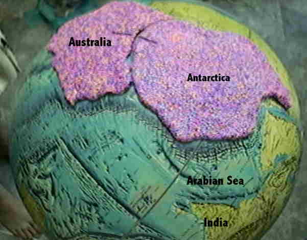
The earth lost approximately 10 % of its circumference and more than � of the crust. It had a gaping wound on one side and the remaining crust on the opposite side. The crust is shattered through out and is broken into sections. These are pulled in opposite directions as they fall towards the lower level wound. Most of the shapes of the continents were determined initially by the cracking of the sub basement shell that occurred during the massive oscillations as the crust was getting close to being removed from the earth. These subbasement cracks are located below the well defined mid ocean ridges. Some of the mid ocean ridges do not have sub basement cracks like the one that exists between Australia and Antarctica. See the Ocean Basins page for more information on this. The shapes of the continents fit the mid ocean ridges. Some surprising clues as to the original locations of the continents becomes apparent. For example look at the comparison of the coast of the combined Australian and Antarctic coasts to the mid ocean ridge that cuts across the Indian Ocean. Job 38 30 The waters are hid as with a stone, and the face of the deep is frozen.
The main continental sections were defined but before they separated much there was a lot of sloshing and pounding that caused the sliding of the faults in the old crust and the folding of the still soft sedimentary layers above them. These formed the mountains like we see on the east coast of North America and the West coast of Africa. The motions of the continents have traced their movements into the molten plastic ocean basins. The edges of the continents had irregularities along their edges that were matched on each side of the split. These left identical marks in the ocean basin as the two parts moved away from each other. They left marks in their wakes that solidified. Much like the marks something would make you dragged it across the surface of soft mud. We can trace these long marks between the continents and move them back together along them. You can see the tracks that India left as it raced towards the Asian continent. You can move South America back into Africa and Australia into Antarctica along these lines that are carved in the basins. Africa along with the Arabian and Indian sections meet Eurasia and the impact of all this momentum creates the Alps and Himalayas. The closure was incomplete between Africa and Europe and this left the Mediterranean basin and the Black Sea Basin. It is interesting to note that the Mediterranean was initially sealed at the straits of Gibraltar and both basins dried up for a short period time. Then as the water levels rose there was a flooding of the Mediterranean and the Black Sea. North America drifted a bit westward over the raised ridge that overlies a sub basement fracture. As the continent moved over the ridge the fractured blocks were raised up and then got jumbled as they bumped over the peak. The entire western middle of the states sits directly on top of that ridge today. The general sloping of the continent from the Mississippi fault to the edge of the Rocky Mountains is due to the underlying ridge.
Here we have millions of years of uniformitarianism continental drift in days.
|
||||
| Mountains and Basin Formations Mountains were formed by combinations of these basic methods. 1. Impacts - The continents as they were smashed into each other. During the approach of the interloper the crust became deeply fractured. Some fracturing went all the way through the first rigid layer. As the continents were jostled back and forth they pounded into each other and caused the folding and bunching up. 2.Up thrusts - The pressure oscillations forced materials upward. These material forced upward through weak fractured crust often encapsulating some pieces and carrying them upward. Other events lifted up whole parts of the crust and these layered sections are now the mountains. They are seen with flat and angled layers up at their peaks 3. Shrinking - The earth’s circumference was reduced after the removal of the crust and underlying denser material. The remaining crustal sections are now trying to fit on a smaller sphere. This has caused bunching up at the new coasts. They are basically wrinkled around the perimeters. 4. Distension - The continents are also distended in the central portions in places. The distension caused ranges and blocks. As the crust distended the individual sliced sections fell over like a row of toppled dominoes. The peaks of the mountains are the corner of the old surface and a side of the section. One side of these mountains is the old surface with topsoil and the other side of the mountain is the geological layers exposed. By mixing and matching these different processes you can create every different mountain in hours instead of the millions of years of uniformitarianism. |
||||
|
The earth is still spewing sand and gravel into the air. During the closest approach, the surface gravity on the interloper side of earth is almost canceled out by the intruders gravity. Materials almost float and land softly. Great gravel is formed some recorded to be as large 6 feet in diameter. Giant boulders are left sitting on top of plains. Large sections of crust are deposited on their sides and sometimes upside down intact. Ayres Rock in Australia is a good example. |
||||
|
The injection of gaseous material from the interior of the earth created a new atmosphere to replace the old removed one and added a tremendous amount of additional water. The conditions on earth were changed at the start of the entire event and rains begin for the first time. The removal of the crust exposed more than half of the surface of the earth to the new molten ocean basins. The water ran off the continents and flowed into the basins where it was turned into steam. The steam condensed and rained down again. Tremendous rains of 20 to 40 inches per hour probably occurred. This went on for weeks. The torrents of water also filled basins in the interior of the continents. As the continents rock back and forth in the backwash of the oscillating earth some of the large fractures open up pathways to the sea and mega flows of water occurred to drain the central basins. These mega flows washed away huge amounts of the still soft sedentary layers that existed in the valleys along the pathways to the sea. The grand canyon drained an area 600 miles by 800 miles. This massive movement cut the entire canyon in a few weeks. The proof that it eroded by draining a huge sea is that the large tributary canyons terminate abruptly with no tributary feeding them. They just stop. This only could occur in this single condition. Another well known type of landmark are the remaining pinnacles and formations of monument valley. The material in-between the monuments is all gone washed away. These areas were the only parts that remain of what was a filled valley of soft material that was all washed completely away. |
||||
|
Some displaced crust was lifted up at the point of departure then fell back to the surface. Some displaced crust walked across due to harmonic resonance. There were tremendous vibrations during much of this activity. These vibrations caused mountains and hills to move laterally with ease. Sands and clays mounded up into hillocks. Sections of continental mass were penetrated by enormous up lifting occurring as the pressures were focused by the oscillations of the crust. By applying these conditions one can explain the creation of all earth’s conditions occurring in a short periods of time. Psalms 114 4 The mountains skipped like rams, and the little hills like lambs. |
||||
| Formation of petroleum and coals Petroleum was formed from the carcasses of fresh meat and fish. The process is really very simple. During the period of time that the waves were performing their work petroleum was formed. These waves would gather at their headwaters large quantities of biomass. The waves were moving and gathering materials at the apex of the deformed earth where the crustal fissures were wide open. The biomass would plunge down into the deep crevasse, many miles deep. The water would flash to steam as it hit the hot and molten rock. The lack of oxygen kept the biomass from burning. The fissure closed up as the earth rotated away from the gravity peak and the crevasse with its material would seal up. The crevasse became a huge pressure cooker that cooked the biomass into petroleum in a few hours. These huge reservoirs of petroleum are way down maybe 20 miles deep. The petroleum seeps upward into sand zones and domes where it collects and we extract it. The formation of coal is very similar except the biomass was carried on the wave front and deposited in the eddy at a displaced slip fault or at the edges of the tidal flow. The waves would gather towards the equator so the flow would move material into bands at the sides away from the equator. Then conditions would cause a large amount of sedimentary deposition on top of the fresh biomass. This would seal the material under the earth where subsequent heat and pressure would convert the biomass into coal. The process is similar to the way charcoal is made today. Here we have millions of uniformitarian years in a few weeks. |
||||