The Ocean Basins Recorded the Motion
During the great cataclysm 3/5ths of the earths crust was removed. My models indicate that both poles and more than half of the outside shell of the earth as well as some of the interior molten material was removed. After the rip-off the remaining crust broke into the continents and moved into the current positions at a very rapid rate.
The ocean basins are now visible for all to see thanks to new earth viewing satellite technology. These images are compiled from measurements of the variations in the ocean surface. Gravity effects the water column and reveals details of the basin itself. The features are striking and are frozen for all to see. My interpretation is that they tell us a story of the events that took place as well as the sequence. The features in the ocean basins prove that a great cataclysm occurred.
The actual final paths of the continental motions are recorded in the ocean basins. We know the crust is lighter and floats on a semi plastic layer of hot dense layer of magma material called the asthenosphere. The bottom of the continents is not a flat surface, it has low and high spots. When the crust broke up and floated apart the magma that it was floating on up welled in its wake. The deeper parts of the crust traced grooves in the magma material as it flowed from beneath the continents. These grooves and the paths of the continents are now recorded in the frozen ocean basin.
Notice the long groves in the photos that follow. These lines show the exact path of the continents.
If you trace from South America along most lines you come to the position in Africa where the continents mated. These lines are altered where additional movement over-road the previous marks.
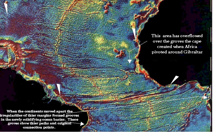
The marks were made by irregularities in the continental margins. If you look closely at the eastern most tip of Africa you see a flow from the North has over flowed over the original marks. This occurred as the African section collided with the Rock of Gibraltar. Africa rotated a bit counter clockwise and dragged the firming basin material over on top of the east west lines that had connected to this point. It is interesting that the current plate tectonic model shows this area just north of the cape as a lot younger than the material that is adjacent. This is called an anomaly, a term attached to an item that doesn't agree wit the current theories.
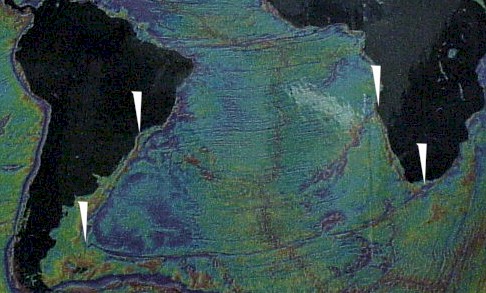
Here we see the two grooves that match up on each side of the Atlantic.
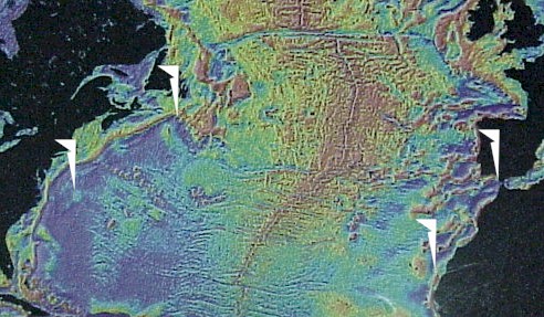
Here we see pairs of point showing where North America and Africa tracked.